
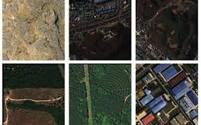
WorldStrat dataset (https://worldstrat.github.io) contains free high- and medium-resolution satellite images with a total area of about 10 thousand square meters. km, which provide a stratified representation of the main land use types around the world.
Each high-resolution image (1.5 m/pixel) is accompanied by several corresponding medium-resolution images from Sentinel-2 satellites (10 m/pixel).
🛢 Data on Zenodo
🖥 Code on GitHub . There are several pre-trained models for increasing the spatial resolution of remote sensing images (the so-called “ super-resolution ”), as well as a python package for creating or expanding a data set.
📖 J. Cornebise , I. Oršolic , F. Kalaitzis . (2022) High -Resolution Satellite Imagery : The WorldStrat Dataset – With Application to Super- Resolution , Advances in Neural Information Processing System 35, Proceedings of NeurIPS 2022. URL: https://openreview.net/forum?id=DEigo9L8xZA