The release states that the data in the section comes from the hydrological network of the RSE “Kazhydromet”, which includes 377 observation points, including: 329 river, 38 lake and 10 sea posts and stations.
As the Hydrometeorological Center emphasized, in addition to monitoring information, the map includes the following modules:
- “Flood Predictors”, which is an important tool for assessing and forecasting flood risk. The module consists of three sections, each of which provides the necessary figures for flood analysis and forecasting, as well as the values of these parameters for the past year and their standard data.
- “Hydrological forecasts”, where the map displays the predicted flood volumes for lowland rivers and the expected average water flow during the growing season for mountain rivers and their norms.
“The data table is updated daily at 12:00 local time.”RGP “Kazhydromet”
For the convenience of users, the interactive map will be supplemented and changed.
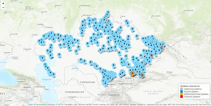 Photo: ecodata.kz
The hydrometeorological center also clarified that when you click on any hydrological post on the map, a table with information appears:
- Name of the hydrological post.
- Dangerous water level in centimeters.
- Actual water level in centimeters.
- Water temperature.
- Actual water flow in cubic meters per second (cubic meters/s).
Recommendations of RSE “Kazhydromet” on the use of the interactive map
https://www.zakon.kz/obshestvo/6445919-risk-pavodkov-kazakhstantsam-otkryli-dostup-k-vazhnomu-instrumentu.html