

Since the institute for studying the reservoir has not actually started working in Kazakhstan, Lada.kz turned to specialists from the Caspian Marine Research Center for clarification. Acting Director Denis Shipilov prepared a detailed response for the editorial board based on research and historical facts.
According to Denis Shipilov, the level of the Caspian Sea has changed frequently during its centuries-long history. Due to the fact that the reservoir is separated from the World Ocean, its level is very sensitive to changes in climatic conditions in the sea basin. During the period of instrumental observations of the Caspian Sea level, the range of its fluctuations was 4 m: from -25.3 m in the eighties of the 19th century to -29.0 m in 1977.
After rising in the 1980s and early 1990s, sea levels have now almost reached the critical levels of the late 1970s, reaching -28.9 m BS in 2023, and are projected to continue to decline in the coming decade.
The main reason for the current decline in the level is the change in the water balance of the Caspian Sea, characterized by an increase in its outflow (evaporation) and a decrease in inflow (precipitation, river runoff). The results of the analysis of long-term observation data indicate that current global climate change has a significant impact on the climatic conditions of the Caspian region. First of all, this concerns humidity and temperature conditions, as well as the associated ice regime in the northern part of the sea.
The average annual air temperature over the past 30 years at marine coastal observation stations has increased by an average of 1.0°C. This has led to an increase in the average surface water temperature over the period by 0.5°C.
With the increase in air temperature, there is a steady tendency towards a decrease in precipitation and an increase in evaporation from the sea surface and adjacent territories. The intensity of the decrease in precipitation was 1.9 mm per year, while evaporation increases by an average of 2.1 mm per year.
Against the background of a decrease in precipitation and general warming, a decrease in the water flow of the rivers of the Caspian basin is observed. In general, the average annual total river flow into the sea has decreased by approximately 35 km3 compared to the previous period of 1978-1995.
Significant warming in the winter season has led to softening of ice conditions in the northern part of the Caspian Sea. The number of severe winters has decreased, the average number of days with ice during the ice period has decreased. The dates of complete clearing of the sea from ice have shifted to earlier dates. Every year the ice distribution zone and the thickness of the ice cover are decreasing.
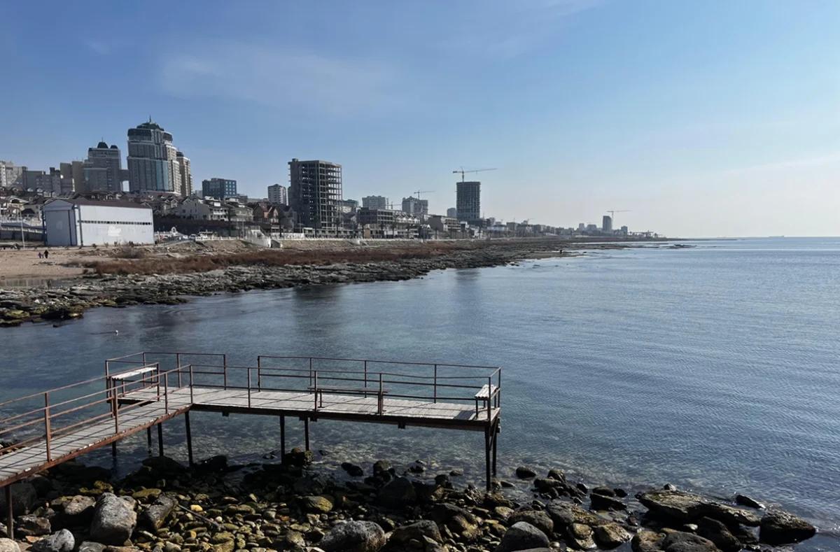
Even small changes in sea level lead to significant flooding or drying of coastal areas. As can be seen from Figure 1, the sea level drop that began in the first half of the 20th century and continued for more than forty years (until 1977) totaled 161 cm and led to the drying of more than 39,332.4 km 2 . The area of the Northern Caspian decreased from 122,127.9 km 2 in 1938 to 82,783.7 km 2 in 1977.

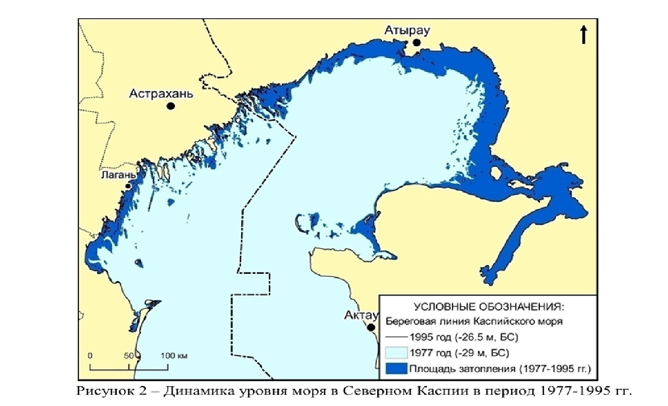
Figure 2 shows that the subsequent rise in sea level between 1977 and 1995 changed the position of the Caspian Sea coastline, especially in its northeastern part. As a result of this rise in sea level, by 1995 the coastline had moved inland in various areas by a distance of 25 to 50 km. The area of flooded land then amounted to about 24,261.7 km 2 . The surface area of the northern part of the reservoir changed from 82,783.7 km 2 in 1977 to 106,983.4 km 2 in 1995.
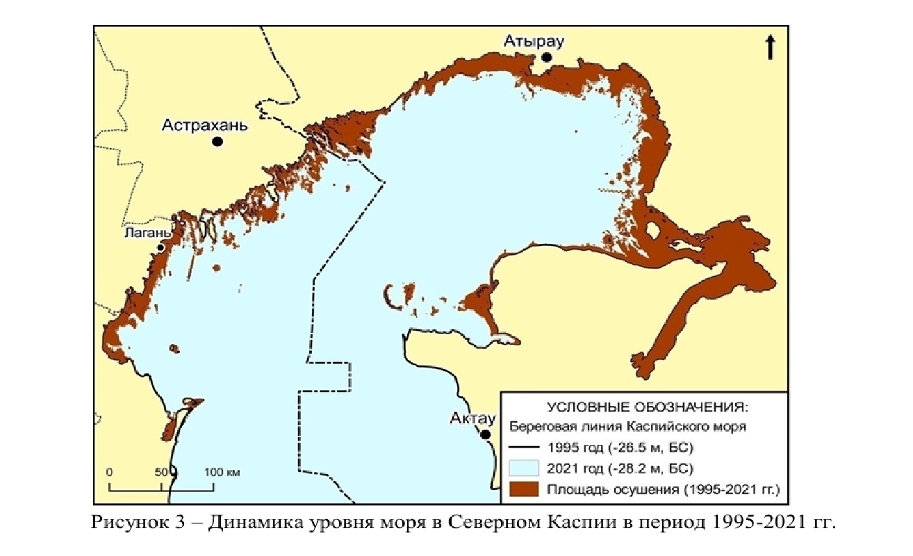
The decline in the sea level that began after 1995 and continues to this day has led to the drying up of the territory in the northern part of the Caspian Sea by 2021 with a total area of about 20,573.7 km2 ( Figure 3). The configuration of the coastline has changed. As a result of the sea retreat (drying up), significant areas of the bottom of the coastal section of the sea came to the surface – more than 50 km wide. The surface area of the northern part of the Caspian Sea changed from 106,983.4 km2 in 1995 to 86,450.2 km2 in 2021.
When comparing the maps presented in Figures 1-3, it is evident that the coastline in the north-eastern, shallowest part of the sea is subject to the greatest changes. In addition, we note that the transgression of 1978-1995 did not recoup the losses of sea area that occurred during the previous drop in level; the area of the sea had decreased by more than 6 thousand km2 by 1995 compared to 1938.
As of the end of 2023, the average sea level was 28.95 m.
To sum up the above, taking into account the actual data and data from forecast models, we can conclude that the Caspian region is currently in an active phase of climate change. A comprehensive study of the patterns of processes that affect the components of the climate environment will make it possible to make significant refinements to existing models of both short-term and long-term forecasting of the development of unfavorable environmental conditions and significantly reduce the economic damage from their occurrence.
In general, the current drop in the Caspian Sea level is caused by natural reasons. Long-term fluctuations in the level in historical terms are cyclical, following the cycles of climate variability. And this must be taken into account when developing adaptation strategies. In these conditions, the provision of timely and reliable hydrometeorological information plays an important role in making effective decisions and developing plans for adaptation to climate change. This task is successfully solved by the Caspian countries within the framework of the Agreement on Cooperation in the Field of Hydrometeorology of the Caspian Sea and the Coordinating Committee on Hydrometeorology (CASPCOM), – concluded Denis Shipilov.
Let us recall that earlier, the deputy of the Majilis of the Parliament of the Republic of Kazakhstan from the Amanat party, Sergei Ponomarev , made an official request to Prime Minister Olzhas Bektenov, voicing the alarming situation related to the current state of the Caspian Sea. He believes that without state intervention, up to five million Kazakhstanis will become environmental refugees by 2040.
International and Kazakhstani experts also studied the problem of the shallowing of the Caspian Sea. In their study, they voiced possible catastrophic scenarios for the development of the situation and put forward a number of proposals for solving the problems. Vice Minister of Ecology and Natural Resources Mansur Oshurbayev spoke about plans to study the Caspian Sea at a meeting in the Majilis on April 22.
For reference
BS – Baltic Height System. A geodetic coordinate system used to determine the height relative to sea level in the Baltic region and neighboring countries.
https://www.lada.kz/in_details/137371-ekologicheskaia-katastrofa-beregovaia-liniia-kaspiia-uzhe-otstupila-na-50-km.html